World Map › Guides
Guide
85% of All Eruptions Since 1900 Trace One Ring. It's the Pacific's
Published · Live Atlas
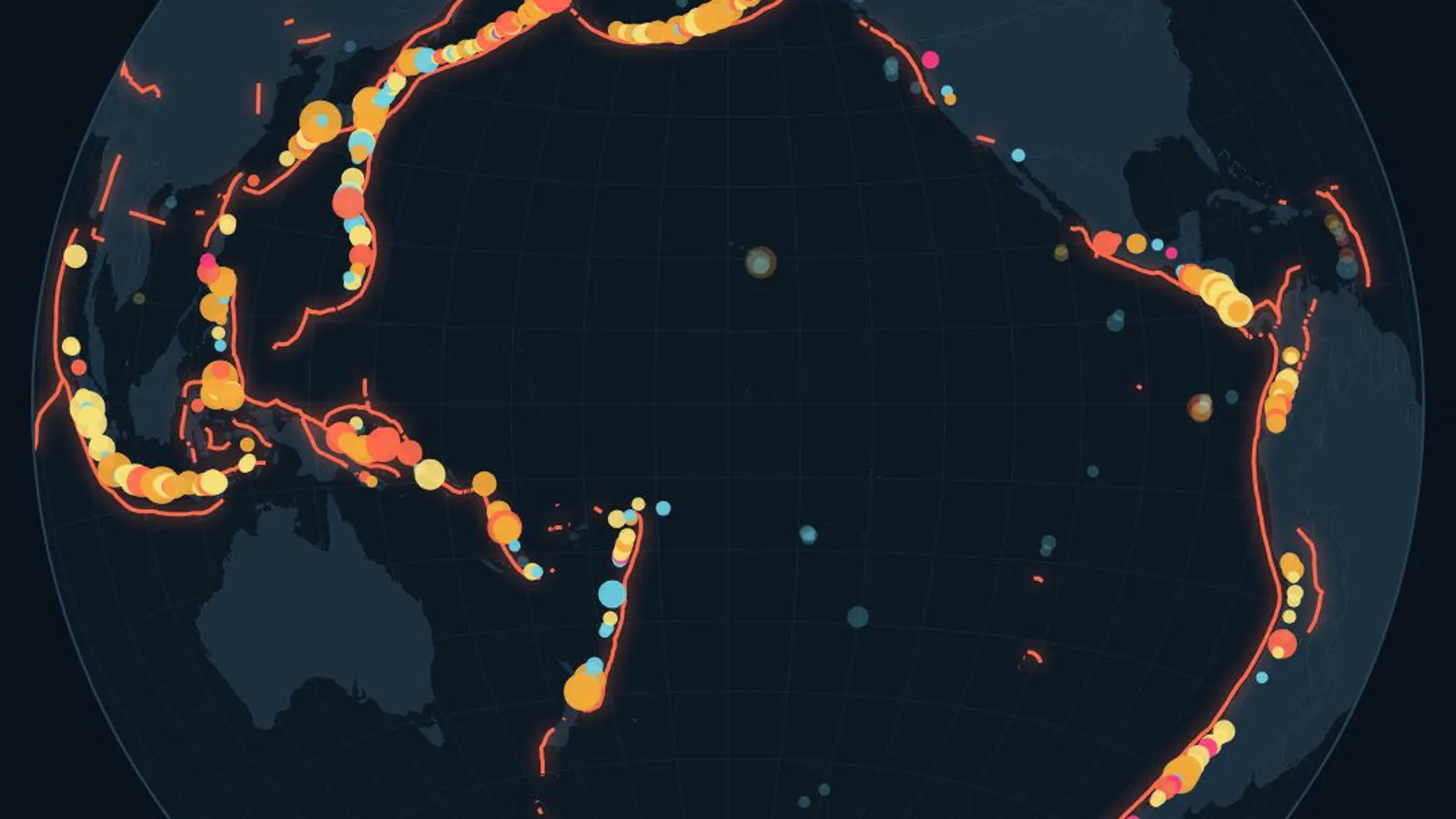
The Ring of Fire is a horseshoe of volcanoes and earthquake zones around the Pacific Ocean, where ocean plates sink beneath their neighbors. Since 1900, 3,784 of the 4,454 eruptions recorded by the Smithsonian happened along it, about 85%.
What Is the Ring of Fire?
It is not a single fault or a single chain. It is a loop of separate volcanic arcs and deep ocean trenches that runs from New Zealand and Tonga up through Indonesia, the Philippines and Japan, across the Kuril Islands, Kamchatka and the Aleutians of Alaska, then down the Cascades, Mexico, Central America and the Andes to southern Chile.
NOAA describes it as more than 450 volcanoes strung over roughly 40,000 km. The USGS adds that about 81% of the planet's largest earthquakes happen along it, which is why the same countries keep making the news for both.
Why the Pacific Is Ringed by Volcanoes
Around most of the Pacific, plates made of ocean floor dive under other plates. This is called subduction. As the sinking slab heads down into the mantle, it releases water trapped in its rocks. That water lowers the melting point of the hot rock above it, and the melt rises to feed chains of volcanoes parallel to the trench.
The same process explains the earthquakes. The plates lock together, strain builds for decades or centuries, then the fault slips. The biggest earthquakes ever measured all struck on these subduction zones, including Chile in 1960 (magnitude 9.5), Alaska in 1964 (9.2) and Japan in 2011 (9.1).
Which Countries Are in the Ring of Fire?
Using the Smithsonian list of volcanoes active in the last 10,000 years, 31 countries and territories have at least one volcano on the ring. These have the most.
| Country | Volcanoes on the ring |
|---|---|
| Japan | 105 |
| Indonesia | 101 |
| Russia | 101 |
| United States of America | 86 |
| Chile | 70 |
| Papua New Guinea | 38 |
| Argentina | 25 |
| Philippines | 23 |
| New Zealand | 22 |
| Ecuador | 22 |
| Mexico | 20 |
| Guatemala | 20 |
The rule used counts volcanoes in a subduction setting around the Pacific (west of 60°W or east of 93°E), Lesser Antilles excluded. Some maps also add the volcanoes of Antarctica or leave out Indonesia's western arc, so totals vary slightly between sources.
Is Hawaii in the Ring of Fire?
No. Hawaii sits in the middle of the Pacific Plate, about 3,500 km from the nearest plate boundary. Its volcanoes are fed by a hotspot, a column of hot rock rising from deep in the mantle, not by subduction. Yellowstone and Iceland are not on the ring either.
Famous Eruptions on the Ring
Mount St. Helens in 1980, Pinatubo in 1991, the second-largest eruption of the 20th century, and Hunga Tonga in 2022, whose blast wave circled the globe, all happened on the Ring of Fire.
See It Live
The map behind this article shows every volcano and plate boundary. Volcanoes erupting right now are highlighted, and you can click any of them to open its page.
Sources
- Smithsonian Institution, Global Volcanism Program, Volcanoes of the World (v5.4.0)
- USGS, Where do earthquakes occur?
- NOAA Ocean Exploration, What is the Ring of Fire?
- Bird, P. (2003), An updated digital model of plate boundaries, Geochemistry, Geophysics, Geosystems
- Live Atlas, eruptions since 1900 counted on the GVP list