World Map › Guides
Guide
What Causes Earthquakes? 14,463 Strong Quakes Draw the Answer
Published · updated · Live Atlas
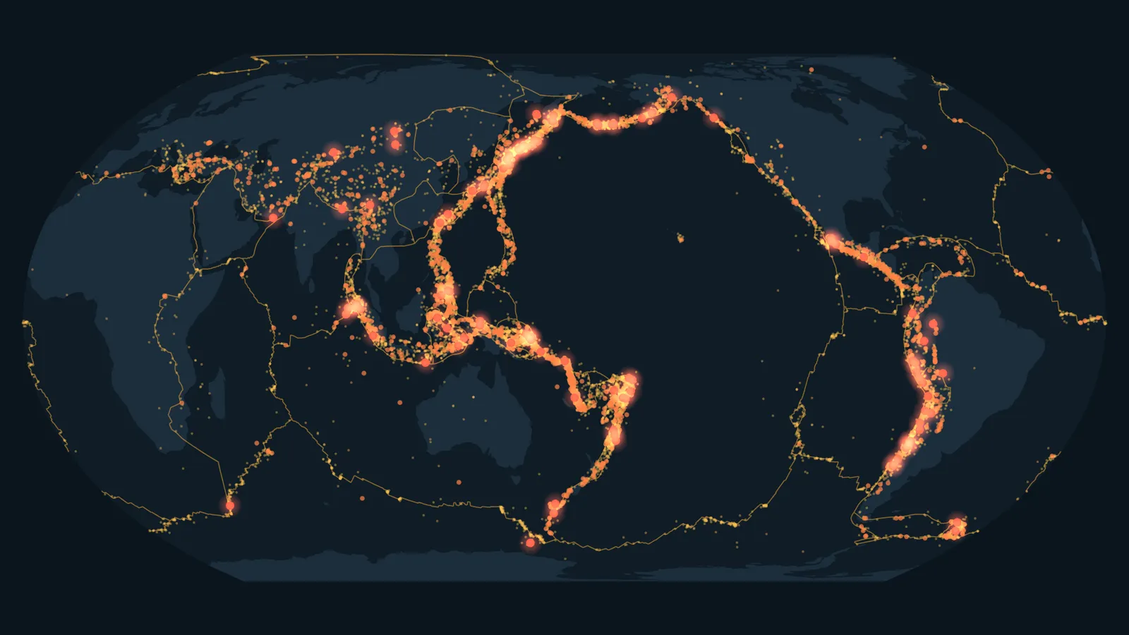
Earthquakes happen when two blocks of rock suddenly slip past each other along a fault, releasing energy that was building up for years or centuries. Most of those faults sit where Earth's tectonic plates meet. Of the 14,463 earthquakes of magnitude 6 or more recorded since 1900, 91.5% struck within 300 km (186 miles) of a plate boundary.
What Actually Happens During an Earthquake
The USGS describes an earthquake as two blocks of the earth suddenly slipping past one another. The surface where they slip is the fault. Deep underground, the rocks keep being pushed, but the jagged edges of the fault stay stuck together by friction. The energy that would make the blocks slide gets stored, like a bent ruler.
When the push finally beats the friction, the fault gives way all at once. The stored energy races out in every direction as seismic waves, and that is the shaking you feel. The point underground where the slip starts is the hypocenter. The spot on the surface right above it is the epicenter, the place named in the news.
Why Earthquakes Cluster Where Plates Meet
Earth's outer shell is broken into tectonic plates that creep a few centimeters a year. Where two plates meet, they grind, collide or pull apart, and the rock along the edge is crisscrossed with faults. In the USGS's words, plate boundaries are made up of many faults, and most of the earthquakes around the world happen on them.
To check how strong that pattern is, we measured the distance from each of the 14,463 strong earthquakes in the USGS catalog to the nearest plate boundary, using the global plate model of geophysicist Peter Bird.
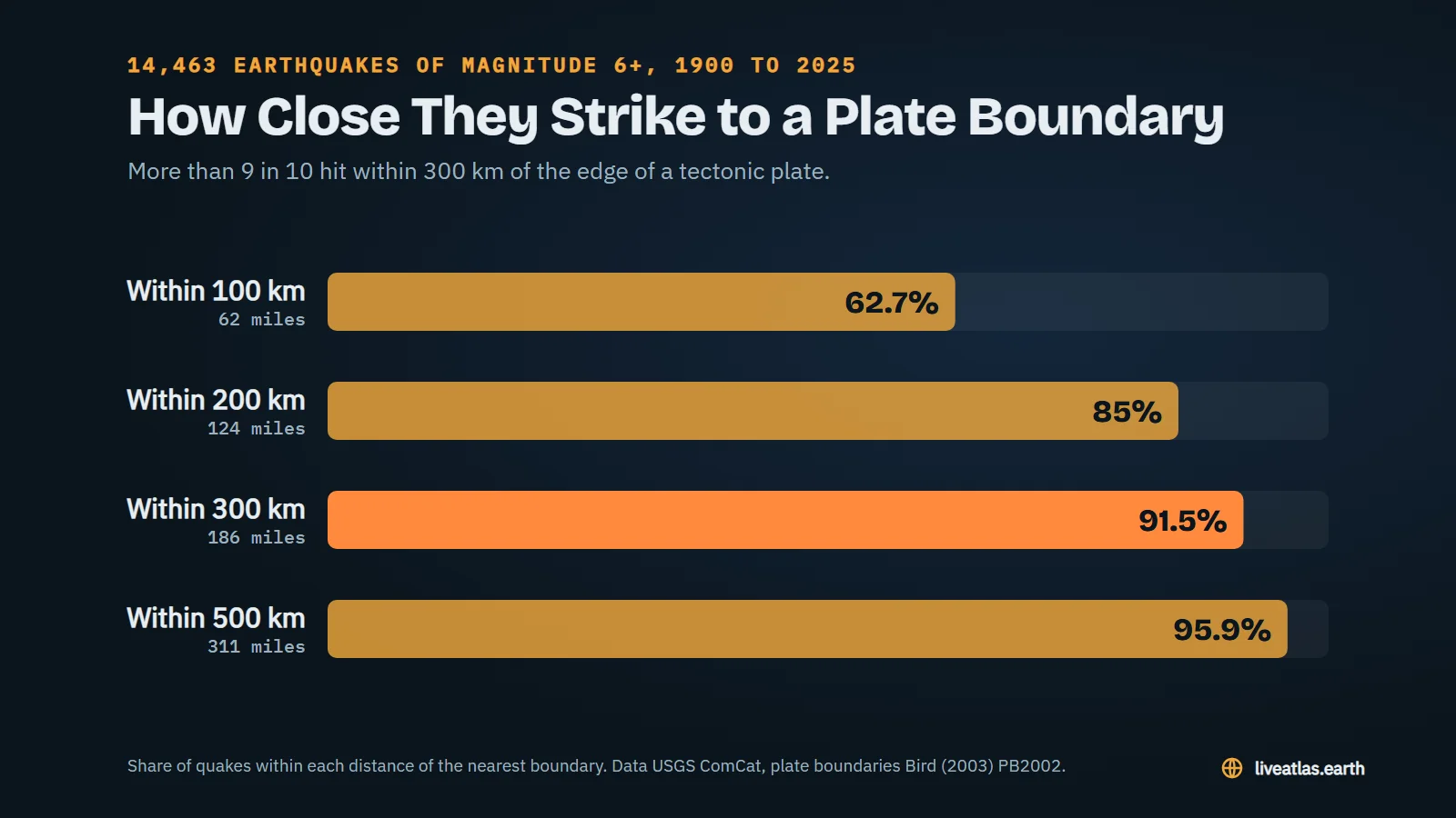
| Distance to the nearest plate boundary | Share of strong quakes |
|---|---|
| Within 100 km (62 miles) | 62.7% |
| Within 200 km (124 miles) | 85% |
| Within 300 km (186 miles) | 91.5% |
| Within 500 km (311 miles) | 95.9% |
The bigger the quake, the tighter the rule. Among the 100 earthquakes of magnitude 8 or more, 93% struck within 300 km of a boundary.
Three Ways a Fault Can Break
How the rock moves depends on what the plates are doing to it. The USGS sorts faults into three basic types.
| Fault | How the rocks move | Where you find it |
|---|---|---|
| Normal | The upper block drops down, the crust is stretched | Where plates pull apart, like ocean ridges and the Basin and Range of Nevada |
| Reverse or thrust | The upper block is pushed up and over, the crust is squeezed | Where one plate dives under another, as off Japan |
| Strike-slip | The blocks slide sideways past each other | Where plates slide side by side, like the San Andreas Fault |
The very largest earthquakes come from the second kind. Where an ocean plate sinks beneath another plate, the locked zone between them can be hundreds of kilometers long, and when it slips, it slips big.
The Biggest Ones All Hit Near a Boundary
Since 1900 the catalog holds 17 earthquakes of magnitude 8.5 or more. Every single one struck within 215 km of a plate boundary, most of them on the Ring of Fire around the Pacific.
| Earthquake | Magnitude | Distance to a boundary |
|---|---|---|
| Valdivia, Chile, 1960 | 9.5 | 109 km |
| Alaska, 1964 | 9.2 | 197 km |
| Sumatra, Indonesia, 2004 | 9.1 | 86 km |
| Tōhoku, Japan, 2011 | 9.1 | 151 km |
| Kamchatka, Russia, 1952 | 9.0 | 94 km |
| Maule, Chile, 2010 | 8.8 | 109 km |
| Kamchatka, Russia, 2025 | 8.8 | 60 km |
Distance from the epicenter in the USGS catalog to the nearest line of the PB2002 plate model. A fault that dips under a continent can put the epicenter well inland of the boundary drawn at the trench.
How Deep Do Earthquakes Start?
The USGS says earthquakes can start anywhere from the surface down to about 700 km. In our catalog, 86% of strong quakes began within 70 km of the surface, the range the USGS calls shallow. But 655 started more than 300 km down, the deepest at 688 km.
Those deep ones are not random. According to the USGS, all earthquakes deeper than 70 km happen inside great slabs of rock that are sinking into Earth's mantle. They are pieces of plates that have already dived under their neighbors and keep breaking on the way down.
The 4% That Break the Rule
591 strong earthquakes, about 1 in 25, struck more than 500 km from any plate boundary. They fall into two groups.
- Deep quakes under the sea floor. 87 of them started more than 300 km down, inside sunken plates. The 2013 Sea of Okhotsk earthquake, magnitude 8.3, began about 600 km below the surface.
- Quakes deep inside continents. Central Asia is the champion. The 1905 Bolnai earthquake in Mongolia reached magnitude 8.3, and a magnitude 8.0 struck Kyrgyzstan in 1911, about 990 km from the nearest boundary. Here the faults run through the middle of a continent, far from the line where two plates meet.
The United States has its own example. The New Madrid Seismic Zone, in the middle of the North American Plate, produced three huge earthquakes in 1811 and 1812.
Foreshocks and Aftershocks
A big earthquake rarely comes alone. The USGS notes that main shocks always have aftershocks, smaller quakes in the same area that can go on for weeks, months or even years. Sometimes smaller quakes come first, called foreshocks, but nobody can tell that a quake is a foreshock until a bigger one follows.
Was There an Earthquake Near You Today?
Our Earthquakes Today page shows every quake on Earth in the last 24 hours, updated by the minute from the USGS. For history, browse the strongest and deadliest earthquakes since 1900, each with its own page.
Sources
- USGS, Earthquake Hazards Program, The Science of Earthquakes
- USGS, What is a fault and what are the different types?
- USGS, Determining the Depth of an Earthquake
- USGS, ANSS Comprehensive Earthquake Catalog (ComCat), magnitude 6 and more, 1900 to 2025
- Bird, P. (2003), An updated digital model of plate boundaries, Geochemistry, Geophysics, Geosystems
- Live Atlas, distance from each earthquake to the nearest plate boundary